


Mallorca Topo Maps
Опис програми Mallorca Topo Maps
+++ Новий GPS-карти App +++
Простота у використанні Outdoor / Offline GPS навігаційний додаток з доступом до кращих топографічних карт і аерофотознімків на Майорці.
++ Для використання в автономному режимі функцій PRO потрібно! ++
Увімкніть Andoid телефон / планшет у відкритий GPS для поїздок в беккантрі БЕЗ клітин охопленні. Ця програма дає вам аналогічні варіанти відображення, як ви знаєте з Garmin або Magellan GPS кишенькових комп'ютерів.
Включені безкоштовно шари карти:
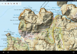
• Майорка Topo Карта: Карта Topográfico Насьональ 1: 50.000 і 1: 25.000 (IGN MTN25 & MTN50)
• Майорка Основна карта: IGN Base Topográfica Насьональ 1: 25,000 (BTN25 & BCN25)
• Майорка образність: Висока роздільна здатність аерофотознімки. План Насіональ де Ortofotografía Aérea (PNOA)
• Реєстрація нерухомості Карта: Cartografía кадастровий
• OpenStreetMaps: Ці Crowdsourced карти є дуже корисним доповненням до інших верствам карти. Містить безліч унікальних особливостей.
• OpenCycleMaps: Ці карти ідеально підходять для планування поїздки на велосипеді
• ESRI Топографічна
• ESRI аерофотознімків
• ESRI Street Map
• Google Дорожня карта (онлайн-доступ тільки)
• Google супутникові знімки (онлайновий доступ тільки)
• Google Map Terrain (онлайновий доступ тільки)
• Bing Дорожня карта (онлайн-доступ тільки)
• Bing супутникових зображень (онлайновий доступ тільки)
• Земля в нічний час
• Hillshading накладення
Основні можливості для зовнішнього-навігації:
• Створення і редагування шляхових точок
• GoTo-Точку-навігації
• Запис треку (зі швидкістю, висоти і профілю точності)
• Tripmaster з полями для одометр, середня швидкість, висота підшипника, і т.д.
• GPX / KML / KMZ Експорт
• Пошук (топоніми, об'єкти POI, вулиць)
• Настроювані поля даних у вигляді карти і Tripmaster (наприклад, швидкість, відстань, компас, ...)
• Частка точками, треками або Маршрути (по електронній пошті, Whatsapp, Dropbox, Facebook, ..)
• Дисплей координати в Lat / Lon, UTM або MGRS / USNG (Військовий Сітка / US National Grid)
• Запис і частка треків зі статистикою & висота профілю
• Поворот карти (Track Up & North Up)
• Отримати Elevation довгими натисніть на карті
• Track Replay
• і багато іншого ...
Доступні функції: Pro (Pro Особливості Доступні через App Purchase)
• використання в автономному режимі - НЕ стільниковий зв'язок не потрібно
• Легкий + Швидка Bulk-завантаження фрагментів карти для автономного використання (не для Google і Bing Maps)
• Створення і редагування маршрутів
• Route-навігації (точка-точка навігації)
• GPX / KML / KMZ Імпорт
• необмежену Waypoints і Tracks
• Додати інші картографічні Плитка-сервер
• Ні оголошень
Використання в автономному режимі:
Всі розглянуті фрагменти карти зберігаються в кеші. Для кешування великих площ, потрібно, щоб придбати Pro функції.
Використовуйте це додаток навігації для активного відпочинку, як туризм, їзда на велосипеді, кемпінг, скелелазіння, катання на конях, катання на лижах, катання на каное, полювання, позашляхові тури 4WD або пошук і порятунок (САР).
Додавання користувальницьких точок маршруту по довготі / широті, UTM або формат МГРС / USNG з системою координат WGS84.
Імпорт / Експорт / Share GPS-Waypoints / Гусениці / Маршрути в GPX або форматі Google Earth KML / KMZ.
Preload БЕЗКОШТОВНО картографічні дані для областей без послуг мобільного оператора (Pro функції!).
Зауваження та побажання до mallorcamaps@atlogis.com
Подивіться на наших інших зовнішніх додатків навігації: https://play.google.com/store/search?q=atlogis
+++ Ми не відстежуємо будь-які дії користувачів або збирати будь-які призначені для користувача дані! +++
Mallorca Topo Maps – Версія 7.7.2
(22-03-2025)Mallorca Topo Maps - інформація про APK
Версія APK: 7.7.2ID пакета: com.atlogis.mallorcaОстання версія Mallorca Topo Maps
Інші версії


Додатки в цій категорії

Вам також може сподобатися...


